Reading the trip reports of others who have taken on the 444 miles of the Susquehanna River from Cooperstown, NY to Havre de Grace, MD were invaluable to me in my planning of my own thrupaddle. An especial thanks to Jay Mackley and Jay Doering for their trip report. With their trip being roughly 20 years ago now, I figured I would publish mine in order to possibly assist other thrupaddlers in the future.
This is the second of two trip report posts. The first post provided information that may help you as you prepare for your own thrupaddle. This post will provide a day by day account of our experiences and what you can expect on the various sections of the river.
This thrupaddle was made between September 21st and October 8th, 2020 (18 days).
If you’re looking for a more emotive and less logistical account, check out The Long Paddle South.
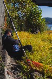
Day 1: Cooperstown, NY – Goodyear Lake, NY
22 miles
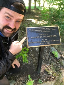
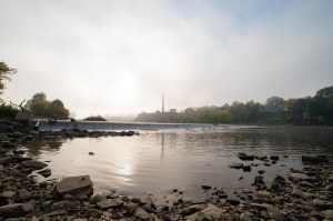
We started out at 7am from Council Rock Park in Cooperstown, NY. Right on the bend where Lake Otsego turns into the Susquehanna. There’s also an official boat launch several hundred feet west at the Fair St Boat Launch. We chose the park due to the official start of the Susquehanna plaque.
Our start was a cold 30F with wind whipping in off the lake. It warmed up slightly as we entered the beautifully foggy river. Half a mile from the start of the river, we were out of our kayaks to portage around our first dam. We got out river left, portaged across the bridge, and put back in river right. Small, windy, and shallow river from there until about river mile (RM) 15 when the water backup from the upcoming Collier Dam on the southside of Goodyear Lake began to become noticeable (deeper water, less/no current).
We ended the day on the north side of Goodyear Lake. Picked up by Michelle’s family and spent the night at their house. Having a bed for the night was nice since our bodies freaked out as soon as we got out of the kayaks – uncontrollable shivering and it took some time for our legs to work properly again. Our bodies had a lot of adjusting to do. 22 miles was less mileage than we had anticipated for the day, but not too bad for how shallow and windy the was.
.
.
Day 2: Goodyear Lake, NY – Wells Bridge, NY
22 miles
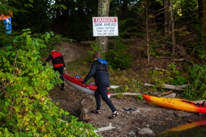
Slightly later start today at 8am. Thick fog covered Goodyear Lake as we paddled to the southwest corner where Collier Dam is located. With limited visibility, we stuck to the western shore of the lake until we got close to the dam and then paddled to the peninsula river left of the dam where the portage is located. The portage is up a steep hill and then down around to the other side of the dam, re-entering river left. This was the second longest portage of our trip.
Water was discouragingly shallow on the south side of the dam and we ended up walking the kayaks for large stretches of day two. It finally did deepen slightly several miles after the dam.
Reached the Oneonta Dam a little after lunch. Official portage is river right and marked with a blue “portage” sign. Word on the river is you can also portage river left and there are several restaurants just up the bank. We had also heard about several natural stone ledges soon after Oneonta that could cause some problems. In high water they’re supposedly runnable down the center. In low water like we had, they’re only passable river left.
We ended the day just north of Wells Bridge. We stayed with one of Michelle’s family friends, thankful to still have warm beds once again.
Day 3: Wells Bridge, NY – Middle Bridge, NY
23 miles
This was our first day both with no dams and with camping out. It was a relatively straight forward paddle with no real obstacles other than lots of shallows to navigate/walk through. Michelle’s family met us in Sidney for lunch. This was the southerly extent of their range so we were properly on our own after lunch.
For the first time, we passed some other paddlers on the river. They were practicing for an annual 70 mile canoe race called the Clinton Regatta from Cooperstown to Bainbridge. We ended up passing Bainbridge mid evening and realized the racers do the distance we did in 2.5 days in mere hours.
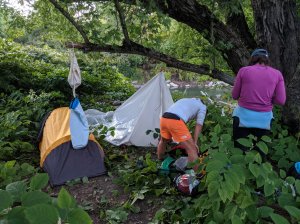
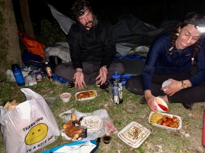
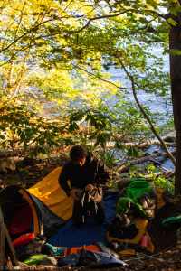
Called it an early night at 5.30pm near Middle Bridge. We found a small, empty island to camp on. We hid the kayaks in the weeds, set up the sleeping situation, had a tuna dinner, and fell fast asleep.
Day 4: Middle Bridge, NY – NY/PA Border
30 miles
Another day of straight forward paddling, but with lots of wildlife this time. Startled a black bear drinking from the river as we rounded a corner. We had hung a bear bag the night before, but re-committed to the practice after the sighting. Also saw a fox later in the day who ran along the river bank with us for some time.
At Zach’s encouragement, we pushed a little harder today and made the PA/NY border just after sunset. We found a remote spot on the shore and set up camp in the dark.
Day 5: NY/PA Border – Binghamton, NY
25 miles
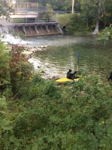
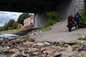
The morning of day five brought us to the Susquehanna Hydroelectric Dam in Susquehanna Depot, PA. The dam is technically breached, but unpassable without portaging. We stuck river left around the islands leading up to the dam and took out river left just before the dam wall. Going river right around the islands would set you up to be easily swept into the breach.
Research says to take out at Susquehanna Depot Access (RM 351) if the Windsor river gauge is 5ft or higher. This would require a one mile portage through town. Our water levels were really low so we approached and portaged with no issue.
We stopped for lunch and a resupply under the Rt 11 bridge in Great Bend, PA. We were hungry and running low on food (we probably should have done our first resupply a day or two before) and there is a good selection of restaurants, gas stations, and grocery stores river right by the bridge.
We ended the day on a remote island just east of Binghamton.
Day 6: Binghamton, NY – Owego, NY
25 miles
Started out the day in thick fog once again as we paddled towards Binghamton’s Rock Bottom Dam. Research had told us there were several old bridge pilons in the river 100m before the dam to give us heads up we were getting close. Technically they are still there, but they’re more islands of rubble in the water by now rather than identifiable pilons.
For Rockbottom Dam, stay river right and portage river right through the park right there.
Approximately 300m after the dam, and right before the Chenango River enters the Susquehanna, is a pipeline running across the water. It might be possible to run at higher water levels. We took out river left and carried the kayaks over.
One mile after the last pipeline, there is another pipline. It runs on both sides of the first big island you encounter after the last pipeline. We took out river left of the right channel, but it looked like you could easily get around the pipeline at any point where it hits the shore.
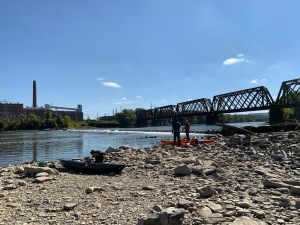
Finally, roughly two miles after the last pipeline is the Goody Power Station Dam and the last obstacle in getting through Binghamton. Stay river left as you approach the dam and portage river left. The portage begins under the railroad bridge immediately before the dam.
We ended the day on a remote island just east of Owego, NY. Zach paddled into Owego for us and brought back Chinese takeout for warm campsite dinner.
Day 7: Owego, NY – Ulster, PA
30 miles
After all the Binghamton obstacles, it felt nice to have a straight forward day of paddling. With this said, we ended up hitting some serious headwinds right as we approached the final NY/PA border and we had to fight them all the way passed Sayre and into Athens.
River was more turbulent than expected as the Chemung River joined the Susquehanna just after Athens.
We made it to a remote island near Ulster about 30 minutes after the sun had set. I didn’t relish paddling in the dark, but it felt good to finally be done with NY.
Day 8: Ulster, PA – Wyalusing, PA
30 miles
Started our day early and stopped to take breakfast at Larnard Hornbrook County Park near Bald Eagle Island. They had water taps and free outlets which were a blessing to get a bit more of a charge in our phones and power banks.
We passed through Towanda later in the day and it looked like a fun little town. The rapids under the bridge in Towanda were fun, but might present a challenge at higher water levels.
Once again, found a remote little island to camp on – this time near Wyalusing.
Day 9: Wyalusing, PA – Tunkhannock, PA
25 miles
Weather forecast had told to us to expect rain on this day and it would be our first rain of the trip. We didn’t enjoy the tought of paddling in the rain all day and then sleeping in rain all night so we scoured our maps and found the riverside Camp Lackawanna which would rent us a cabin for the night.
Sure enough, rain started at 10am and continued sporadically all day. We stopped for lunch and a resupply in Meshoppen. Learned that there is a lot of fracking in the area and locals don’t drink the tap water. There’s also a limit to how many fish people are allowed to eat from the river each month. Made a mental note to not filter water in this area but drink bottled water which we stocked up on in the gas station.
We had had fun little rapids throughout the day, but we had read warnings about the rapids soon after Meshoppen. If the Meshoppen river gauge is 9+ feet, the rapids are a class one. Our water levels were so low that the rapids were easy and fun.
We arrived at Camp Lackawanna by 4pm. We could’ve gone further but with a cabin reserved and having already gone 25 miles, we designated this a rest day and enjoyed having a roof over our heads and warm showers.
Day 10: Tunkhannock, PA – Pittston, PA
29 miles
The big celebration today is that we passed RM 222, the halfway point of the thrupaddle!
We stopped in Tunkhannock for a proper resupply. There is a riverside CVS which had literally everything we could dream of and we ate well!
Immediately after Tunkhannock we passed through a barely submerged boulder field. We were scraping and hitting them left and right which made going slow and infuriating. Thankfully none of the boulders succeeded in capsizing any of us.
We ended the day in just north of Pittston.
Day 11: Pittston, PA – Wapwallopen, PA
31 miles
Discovered the Lackawanna River enters the Susquehanna right across from where we camped for the night. The Lackawanna is heavily polluted by acid drainage from abandoned coal mines upriver. The entire river left of the Susquehanna was stained a scary rust color for the rest of the day. Evident of the pollution was still with us days later when every paddle we took would stir up rusty sediment from the river floor.
We encountered a pipeline just after the Lackawanna enters the Susquehanna and just after the railroad bridge there. The pipe is supposedly exposed and sharp a low water levels. We stuck river left and had no issues.
Just after Nanticoke are the Nanticoke Rapids (or Nanticoke Falls as some call them) which are class 1 at high water levels. Research said experienced paddlers can shoot down the middle while less confident paddlers should stick river left. At our low water levels, left was the only option and we made it through with no problems, but they were the fastest rapids we experienced during our thrupaddle. Be careful.
Made it Wapwallopen by 7pm and were picked up by my friend Adam who now lives in the area and gave us a warm floor to sleep on and the chance to do our laundry! With only two pairs of clothes (one for paddling and one dry pair for camping), it was a godsend!
Day 12: Wapwallopen, PA – Danville, PA
28 miles
Adam joined in for most of our day 12 paddle. He unfortunately got to experience the double whammy of extremely shallow water and a strong headwind from Wapwallopen to Berwick.
Under the bridge in Berwick is Nescopek Falls which is “very hazardous at low water levels (2ft or less on Berwick river gauge).” It’s maybe a five foot waterfall at our low water levels right in the middle of the river. We kept far river right and were able to take a channel around it with no problems.
Adam left us when we got to Bloomsburg and we continued on to Danville for another night of island camping.
Day 13: Danville, PA – Herndon, PA
24 miles
Early in the day we came to the confluence of the Susquehanna north and west branches which was kept calm by the water backup from the coming Sunbury Fabri Dam. The confluence was massive and felt like it was a mile across.
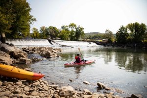
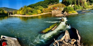
The Sunbury Fabri Dam is an inflatable dam (supposedly the largest inflatable dam in the world) just south of the confluence. We kept river left and portaged river left with no problem.
There’s a pipeline to portage one mile south of the dam. We took the river right channel and portage river left of that channel.
River took on a different character from here on out. It was very wide with massive islands. The left and right sides seemed to have decently deep channels, but the center was unpaddably shallow. It seemed best to just pick a side and stay there. We stuck with river right until we had to cross to river left in order to end the night in Herndon where my family picked us up and transported us to Zach’s family’s cabin in Herndon. Another night with a roof over our heads!
Day 14: Herndon, PA – Duncannon, PA
26 miles
My sister Emma joined us for our day 14 paddle. Similarly to Adam a few days ago, she was treated to the frustrations of early morning shallow paddling. Thankfully the river soon deepened and the current picked up to the swiftest it had been all trip!
We took lunch in Millersburg to check out the last ferry operating across the Susquehanna. Of course it was not running while we were there as the water was too shallow.
We made it to Duncannon to end the day. We were once again met by my family and transported to their home for the night.
Day 15: Duncannon, PA – Middletown, PA
25 miles
We started the day out in a boulder field which would have been frustrating without the local paddling route maps provided for free on the Blue Mountain Outfitters website (and re-posted in my preparation resources post).
We soon approached the Dauphin Narrows which can be sketchy rapids. Easiest and safest route through is far river left and then stay river left. We ended up staying river left all day, but stay river left at least until after the Rockville Bridge (longest stone arch bridge in the world).
As I said, we stayed river left into Harrisburg and had lunch on City Island with my other sister Hannah who lives in Harrisburg. Then right after city island, we stuck river left and portaged around the Dock Street Dam which wasn’t hard, but was the dirtiest portage of our trip.
From there it was just a long straight paddle to Middletown where we were yet again met by my family who transported us to Zach’s family’s house for the night.
Day 16: Middletown, PA – Washington Boro, PA
24 miles
Started out in the thickest fog of the trip which was disorienting and intimidating as there are restricted waters around the Three Mile Island ex-nuclear power plant right there at Middletown. We entered the river river left and paddled over to the river right shore. The river left shore is home to a small dam and the restricted waters. Continued river right until we hit the York Harbor Dam which turned out to be the longest portage of the trip at 0.4 miles long.
Long straight river for the rest of the day with no real obstacles.
Once we hit the Columbia-Wrightsville Bridge, the water started to slow down and we technically entered Clarke Lake which is made from the water back up due to the Safe Harbor Dam we would tackle tomorrow.
We ended the day in Washington Boro which is the last river access before Safe Harbor Dam. We were picked up by Zach’s family and transported to their house for one last night in a warm bed.
Day 17: Washington Boro, PA – PA/MD Border
26 miles
This was a day of dams and lakes. We started by finishing the Lake Clarke section of the Susquehanna and arrived at Safe Harbor Dam. Safe Harbor is the first of three dams on the Susquehanna that you can’t portage yourself around and have to schedule the dam company to portage you around. I had called Brookfield Renewable (508-251-7744) who runs both Safe Harbor Dam and the upcoming Holtwood Dam. I had called them from City Island on day 15 to schedule both portages for today, day 17.
We made it to Safe Harbor by our scheduled portage time. We approached river left and took out at a concrete pier. There was a phone to call them to let them know we arrived. Soon two maintenance guys arrived, loaded our kayaks onto their rack, drove us around, and released us in a small stream leading into the Susquehanna just south of the dam. An easy and painless process.
It’s roughly seven miles from Safe Harbor to Holtwood and I had put three hours between our scheduled pick ups. Between these two dams the Susquehanna also goes by the name Lake Aldred and as paddling on a lake is always slow due to the lack of current, we were a little late for our pickup.
Adding to our lateness was the confusion about where the portage was. As you approach the dam, it looks like the portage would be river left as that’s where all the buildings are. To confirm this, there is a sign in the middle of the river saying the portage is river left. But we had read online that the river was portage right. We ended up going river left (who were we to argue with an official sign), but there was nowhere to get out river left with all the driftwood blocking the shore. Soon a minivan drove up to the parking lot maybe 300m away and a guy got out, shouting to us that the portage was river right so we paddled over to the river right shore.
To be clear, the Holtwood Dam portage is river right. There’s no easy take out spot, but stay river right, take out as far south as you can without crossing the buoy barrier, walk up to the small road (maybe 20 feet from the river), go left, and there is a small building at the Holtwood Dam Overlook with a portage phone for you to call Holtwood and let them know you are there. We were soon picked up and dropped just south of the dam in what is once again still the Susquehanna but also known as Lake Conowingo.
From there it was. along straight paddle to the PA/MD border where we found a remote camping spot on the shore. A word of warning, the sides of Lake Conowingo are extremely steep. It’s hard to find a place to exit the lake and when you do, it’s even harder to find a flat spot to sleep. We eventually did find one, but it was the most difficulty we had in finding a campsite all trip.
Day 18: PA/MD Border – Havre de Grace, MD
14 miles
On the morning of day 17, we had called Excelon (888-457-4076) who manages the Conowingo Dam in order to schedule our portage around their dam as there was yet again no self portage. For the Conowingo portage you do not paddle up to the dam as we had with every other dam. The Conowingo portage is river right at Glen Cove Marina roughly 1.5 miles north of the dam. It’s the last easily accessible take out spot before the dam. A Excelon employee met us at the marina, loaded our kayaks into his truck, and put us back in south of the dam. Piece of cake.

The Susquehanna was finally a river again on the south side of the dam. From there, we navigated through. a boulder field which probably forms some rapids at higher water levels and we had a tail wind all the way to Havre de Grace.
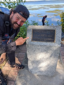
In our research, we never found an official end point of the Susquehanna so we just guessed by looking at the map. The river seemed to take a pretty hard right at Concord Point Park so we decided that was going to be our end point. Luckily for us, Concord Point is the official end of the Susquehanna with an almost identical plaque as the one we started out with in Cooperstown’s Council Rock Park 18 long days ago.
If you haven’t already, you can read about our preparation and planning for our Susquehanna thrupaddle here.
If you haven’t had enough, you can read a more emotive/qualitative/experiential account of the thrupaddle here titled “The Long Paddle South”.

Hi Joel, my wife and I were planning on trying to kayak the whole Susquehanna starting in a couple of weeks and we have been poring over your logs for the last couple of months. They have been extremely (hypothetically) helpful so far. I did have a question regarding permits – do we need permits from either the states of New York, Pennsylvania or Maryland to be on the water?
Hey lecornwi! So as far as I could find, you don’t need permits for either NY or MD. In PA, you don’t need a permit to be “on the water” but you do need to register your boat or buy an annual “launch permit” in order to use state run launch spots. You can use non-state launches to get on and off the river, but it’s easier just to buy one and not worry about it. Long answer short, I bought a permit for PA and that’s it.
Shoot me an email with any questions you might have (joelwitwer@gmail.com) and I’d love to see any photos or blogs of your trip if you put them out into the world!