Reading the trip reports of others who have taken on the 444 miles of the Susquehanna River from Cooperstown, NY to Havre de Grace, MD were invaluable to me in my planning of my own thrupaddle. An especial thanks to Jay Mackley and Jay Doering for their trip report. With their trip being roughly 20 years ago now, I figured I would publish mine in order to possibly assist other thrupaddlers in the future.
This is the first of two trip report posts. This post will provide resources as your prepare for your thrupaddle. The next post will outline our experiences and obstacles on a day to day basis.
If you’re looking for a more emotive and less logistical account, check this post out.
If you want to skip to the daily logs, you can do so here.
This thrupaddle was made between September 21st and October 8th, 2020 (18 days).
THE TEAM
This part probably isn’t necessary for a trip report, but it’s still fun so here we go.
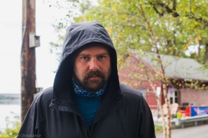
Zach Miller is a professional mountain runner and an experienced outdoors man. Zach grew up along the Susquehanna in Columbia, PA. When I was thinking of people to join the adventure who didn’t have regular jobs and could afford to take 2-3 weeks off for the attempt, Zach was at the top of my list.
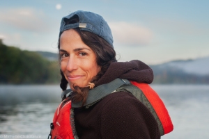
Michelle Christiance is a professional photographer and an avid outdoors enthusiast. Michelle grew up along the Susquehanna in Oneonta, NY. Originally I was asking if I could stay with her parent’s at her childhood home the night before setting off and once Michelle heard what was up, she was instantly on board!
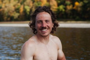
Joel Witwer – yours truly – works in communications for a non-profit. I grew up along the Susquehanna in Hershey, PA. I knew a the small stretch from Harrisburg to Lancaster, PA but always kind of wondered where it came from and where it went. This was the adventure to find out the answers to those questions.
.
THE KAYAKS
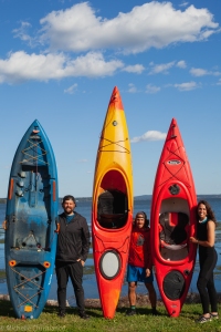
Zach was in a Perception Montour 12.0 borrowed from his uncle.
Michelle was in a Pelican Escape 100 borrowed from her mother.
I was on a Lifetime Teton Angler borrowed from my parents.
While I’m a big fan of using what’s available for your adventures, I will say a sit on top kayak is not ideal for a paddle such as this one. I think I proved that it is possible (and may have been the first person to do so), but if you have another option, I would recommend you take it. Sit on tops are slow, heavy, and bulky although the seat was nice and it was handy to hop in and out of through the shallow water.
THE PACKING LIST
| Storage – 2 40 gallon dry bags – 1 10 gallon dry bag Camping – 1 sleeping bag – 1 sleeping pad – 1 ground tarp (5x10ft) – 1 painter’s plastic sheeting (10x15ft) – 1 long length of cord rope Camp/Dry Clothes – 1 t-shirt (cotton) – 1 sweater (wool) – 1 pair of sweats – 1 pair of wool socks – 1 wool hat – 1 neck buff Kayaking/Wet Clothes – 1 pair of quick dry trousers – 2 pairs of athletic underwear – 1 quick dry long sleeve shirt – 1 rain jacket – 1 pair of river shoes – 1 baseball cap – 1 life jacket (PFD) – 1 pair of gloves | Misc – maps – knife – first aid kit (bandaids, antibiotic cream, advil, alcohol wipes, etc) – moleskin – kayak patch kit – headlamp – water filter – camera – emergency whistle – 1.5L water bottle – toiletries (toothpaste, toothbrush, soap, etc) – water purification tablets (didn’t end up using) – poop shovel – toilet paper – sunscreen – bug spray – phone (with Google Maps) – power bank to recharge phone – lots of ziploc bags – wallet (cash, credit, ID) |
Notes:
- Many people recommend bringing a backup paddle in case you lose yours. None of us did and it worked out for us, but it’s a calculated risk.
- If you’re in a sit-in kayak, a sponge is a must.
THE FOOD
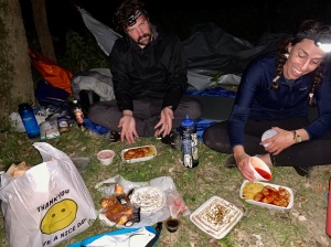
First and foremost, this was not a wilderness trip. We were never more than an hour from some small riverside town. We never carried more than two or three days worth of food. And we made the call not to carry anything that needed cooked in order to reduce our packing list (no camp stove, etc). We had a few meals from riverside restaurants and gas stations, but we mostly resupplied with things like tuna, protein bars, nuts, granola, fruit, and so on. We’d often scan ahead on Google Maps and identify towns with gas stations, pharmacies, restaurants close to the river as they weren’t always visible from the river.
THE (DRINKING) WATER
We filtered water from the river the whole way. We heard other people advise to both filter and treat water south of Binghamton. We started doing this but, for better or worse, we reverted back to just filtering after a bit. Especially once we hit PA for the second time, we tried to fill up in campgrounds and gas stations as much as possible due to excessive fracking in the Endless Mountains region and very visible industrial mining pollution just north of Pittston, PA which stains the river for the next several days.
THE LODGING
We were blessed to have family and friends along the river who provided us beds for 7 out of the 18 nights. We also lodged in a riverside cabin (Camp Lackawanna near Tuckhannock, PA) during what was forecasted (and was) a night of rain. The rest of the nights, we found remote areas to wild camp in. If there were “No Trespassing” signs, we would find a different spot. We preferred camping on islands rather than on the shore and would scan ahead on Google Maps at the beginning of each day to see what island options there were around our predicted destinations. Some days we had to push ourselves further than we anticipated to get to a suitable island and some days we cut ourselves short in order to end at an appropriate island campsite.
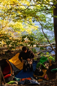
Michelle brought a one person tent with her. Zach also brought a one person tent, but never used it only sleeping in his bivy bag. I had plastic sheeting that I strung up as a cover the first few nights, but soon abandoned it to just sleep openly (ground tarp, sleeping pad, sleeping bag).
We were blessed with great weather and never had to sleep out during a rainy night of which there were three (one we knew was coming and found a riverside cabin to rent – the other two we were staying with friends and family).
.
THE MAPS
Collecting maps and water trail guides for the entire length of the river was an exercise in research as it was not easy. Below are the maps I found and we used, but all are best used in conjunction with Google Maps and any local advice you can glean.
Every year there is a 70 mile canoe race from Cooperstown to Bainbridge called the Clinton Regatta. Their maps seems to be widely regarded as the the best maps for this first 70 mile section of the river. I couldn’t find an actual map, but did find an old (2006) guide detailing hazards and accesses along the 70 miles. As of 2020, their tips and photos are still accurate and helpful. Only note is we didn’t notice or experience anything out of the ordinary at what they call the Unadilla Dam.
Cathy Mumford said she used USGS topographic maps for the NY sections and claimed they worked great for her. We didn’t, but I figured I’d throw that out there as an option.
2. Bainbridge, NY – Afton, NY
No maps. Use Google Maps, but really it’s just normal river. No hazards.
This is an old map (1970’s) detailing most of the remaining NY sections of the river. It may be old, but it still has all the info you need as people don’t go building dams all willy nilly. For the brief PA section around Susquehanna Depot and Great Bend PA, switch to the 2nd NY/PA Border – Sunbury Map (coming in a hot second) as it also has this small first PA section in it.
4. Owego, NY – 2nd NY/PA Border
No maps. Use Google Maps. No hazards of note though.
This is referred to as the North Branch of the Susquehanna and the maps for it are easily the best maps of the trip. They point out hazards and portages and just gives solid advice for each section of the river. They also give river miles, amenities at access points, point out possible riverside lodging, etc. They’re also available for free download from Endless Mountain Heritage.
Great map, but I couldn’t find any digital version of it beforehand so I bought the physical copy from Blue Mountain Outfitters (BMO) in Harrisburg, PA (you can call them and they’ll mail it to you). A slightly concerning note is rumor has it these maps are out of print so they may become harder to find as time goes on. As of 2020, BMO still had a healthy supply. The Susquehanna River Trail Association has a list of retailers supposedly carrying the map. I’ve uploaded a low quality digital copy above, but it worth buying the actual map. I’d try for a higher quality reproduction, but I capsized and lost the physical map. Two corrections to this map though:
- The fabri dam at Sunbury is not impassable as the map claims. Stick river left and portage river left.
- The “dam” just after the fabri dam is also not impassable as the map claims. Additionally, it’s more of a pipeline than a dam. We took the river right channel around the island and portaged river left of that channel.
Also worth having is BMO’s paddle guide (map and description) for the Dauphin Narrows and Rockville Bridge as you approach Harrisburg. While I’ve provided downloads below, both files and more are available on the BMO website.
7. Harrisburg, PA – PA/MD Border (Lower Section) Map
Another great map, but also without a digital presence. I bought my physical maps online from the Susquehanna National Heritage Area and they mailed them to me. The rumor also says these are out of print, but as of 2020 SNHA still has copies for sale. I did not take photos of these maps before I lost them so I have no low quality digital copy to help you out. Sorry.
8. PA/MD Border Map
I never found official maps for the Maryland section of the river. We relied on Google Maps with no issues. Only big hazard is the Conowingo Dam.
THE TIMEFRAME
We did our thrupaddle from September 21st – October 8th (18 days) which put us directly during the end of Summer and beginning of Autumn. It was indeed possible and we did complete the thrupaddle, but with the added obstacle of chronically low and slow water the entire way. Adding to our troubles were we completed our thrupaddle in the midst of a drought and heard the remark from people all along the river that this was the lowest they had ever seen it.
I had read accounts of people who had completed the river in as little as 11 days (Jay and Jay) and as long as 26 days (Cathy). I had ambitiously thought we could do it in 14 days which would have required an average of 32 miles per day. We ended with an average of 25 miles per day. The thrupaddlers who completed the paddle faster than us were probably stronger paddlers than we were, but also made their trip in late spring and early summer when the water is both deeper and faster. If I were to make the paddle again, I would attempt it earlier in the year to make the paddle easier.
The one benefit of low and slow water was that the rapids along the river were much easier and safer to navigate for novice kayakers such as ourselves.
THE HAZARDS
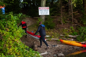
Dams – The most dangerous aspect of the river were the dams we had to navigate around. Most are well marked, but you should be aware of where each one is and approach cautiously. Most are rather small, but could end your thrupaddle should you fall over or get caught up in one. You are not allowed to portage around the last three dams (Safe Harbor, Holtwood, and Conowingo). You’re supposed to call a minimum of 24 hours before you arrive and they will portage you around their dam in a truck. I believe if you need a portage over the weekend, they ask you call 48 hours in advance. It takes some planning, but is doable.
Safe Harbor Dam is run by Brookfield Renewable and you can schedule your portage at (508) 251-7744.
Holtwood Dam is also run by Brookfield Renewable and can also be reach at (508) 251-7744. I scheduled both our portages on the same call. There are only seven miles between the two dams, but be warned the water is still and there is no current to help you so the paddle from Safe Harbor to Holtwood may take longer than you anticipate.
Conowingo Dam is run by Exelon and you can schedule your portage at (888) 457-4076.
Rapids – There are numerous rapids along the river. Since we did our thrupaddle in such low water, we had no trouble, but some can be tricky at high water levels. The above maps give warnings for the more difficult rapids.
River Flow – Our river was slow, but sections can supposedly be tricky at higher water and flow levels. Keep on eye on the river gauges and be careful.
Electric Storms – We never experience these on our thrupaddle, but other thrupaddlers have and recommend getting out of the water while they are close.

While not a kayak person I thought the article was very interesting and inspiring. you all overcame certain adversities and accomplushed what you set out to do. Your story should be told to all students in schools demonstrating what can be done if one puts their mind to it. Well written and I wonder if you could be a write and not know it. Way to go from a retired high school chem teacher. How about the next river you try is the Lehigh river?
Thanks Larry! It was both a challenging an rewarding experience. Who knows, maybe I will try the Lehigh River someday, but I’m going to rest for a while now haha
Your comments and experiences are appreciated. I am thinking of the Cooperstown to Sunbury stretch early this summer. As a 66 year old with shoulder issues the trip will be dependent on my practice runs. Used to do the Herndon to Millersburg run years ago. I like wildness and few people -will the upper run give me that?
Hi William. The upper run will absolutely give you that. The river up there is completely different than what you’ve experienced Herdon-Millersburg! It’s a lot smaller and we saw more wildlife up there – deer, bears, otters, foxes, etc. Let me know if I can help at all!
Thanks. I’m thinking June 1st if water is right.
Great! Let me know if I can help at all and Id love to hear about your experiences when you’re done!
Joel, great article and help. Im planning the trip next summer. I was trying to access the jay’s trip report but when I tried to go through the link at your site, it was reported that the site was corrupted. Do you have their direct link?
Also, was hoping to ask you some specific questions off site if you are ok with that.
Thanks,
Jim
Hey Jim. It looks like the site that was hosting their trip report is no longer in existence. I used an internet archive tool to find it. The photos aren’t there anymore, but you can see what they wrote: https://web.archive.org/web/20210309162840/http://www.seakayak.ws/kayak/kayak.nsf/a631f4790e66c273852569f9006ec1b2/3e10fe30a47c4cba852570db0042bf9d!OpenDocument
Sorry. This was me but forgetting to log in.
And yeah, feel free to ask any specific questions you like. My email is joelwitwer (at) gmail